7/06/2017
M 6.5 - 3km NNE of Masarayao, Philippines
By: Gordon Rutherford
M 6.5 - 3km NNE of Masarayao, Philippines
UTC Time = 2017-07-06 08:03:57
Magnitude = 6.5m
Location = 11.114°N 124.633°E
Depth = 6.5 km
Drivers:
Sun at 150 degrees from the Moon
Combinational Drivers:
- Saturn at Lunar Conjunction
- Sun, Mercury, and Mars at Geocentric Conjunction
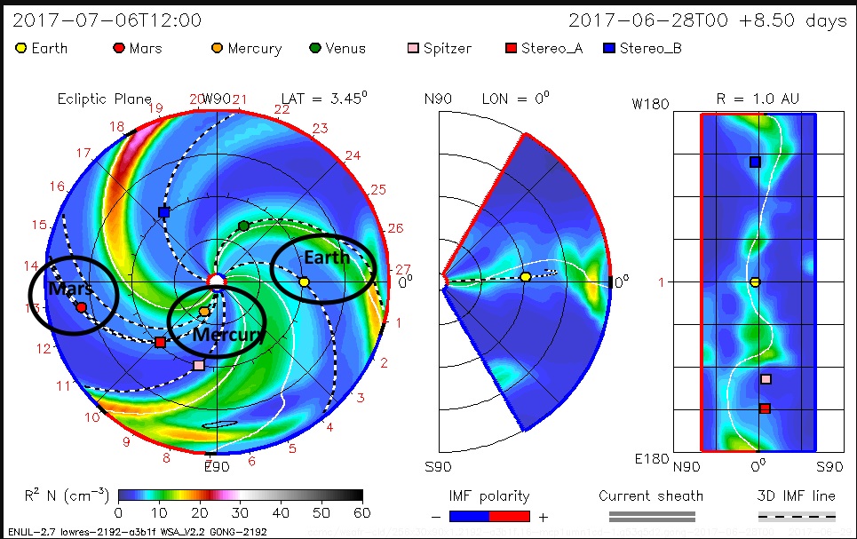
Solar Magnetic Field:
- Earth/Moon (Para-Magnetic) Neutral
- Mars (Para-Magnetic) Negative
- Mercury (Dia-Magnetic) Neutral to Positive
Epicenter Skyview
NASA JPL Data
Rotating Solar Magnetic Field
Earth/Moon Magnetic Field
7/05/2017
M 5.8 - 11km SSE of Lincoln, Montana
By: Gordon Rutherford
M 5.8 - 11km SSE of Lincoln, Montana
UTC Time = 2017-07-06 06:30:17
Magnitude = 5.8m
Location = 46.871°N 112.603°W
Depth = 13.6 km
Drivers:
Neptune Rise, Moon Median, while Neptune @ Western Lunar Elongation
Combinational Drivers:
- Saturn at Lunar Conjunction
- Jupiter and Neptune at Geocentric Opposition
Solar Magnetic Field
- Earth/Moon in the Neutral to Negative
Epicenter Skyview
Antipodal Locations
Antipodal Skyview
NASA JPL Data
6/30/2017
Celestial Geometries - 06/30/2017
By: Gordon Rutherford
Reports assembled using the NASA JPL Horizons Data, NOAA DSCOVR Real-time Solar Wind Data, Solar System Scope, The Planets Today - Geocentric View, and the WSA-ENLIL SOLAR WIND PREDICTION websites and analysis tools...
Lunar Geometries
Mars at Lunar E. Elong
Neptune at Lunar 150 Degrees
Combinational Geometries
- Sun, Mercury, and Mars at Geocentric Conjunction
Rotating Solar Magnetic Field
- Earth/Moon in Negative
NASA JPL Horizon's Data
NOAA Solar Wind Data
6/21/2017
ML 4.0 - CRETE, GREECE
By: Gordon Rutherford
ML 4.0 - CRETE, GREECE
UTC Time 2017-06-21 12:46:03.3
Magnitude ML 4.0
Location 35.32 N ; 24.46 E
Depth 67 km
Drivers:
Saturn at Geocentric Opposition to the Sun
- Earth crossing Saturns connected path to the Sun
WEBSITE:
https://www.emsc-csem.org/Earthquake/earthquake.php?id=600030
Epicenter Skyview
Antipodal Locations
Anitpodal Skyview
NASA JPL Data
Heliocentric View
6/19/2017
EMSC Earthquake Analysis - 06/19/2017
By: Gordon Rutherford
EMSC DATA downloaded
DATE 06/19/2017
TIME 23:50:55
Number of quakes >2.5m 56
Highest Magnitude Quake
Depth = 265
Magnitude = 5.8
UTC Time = 09:15:43
FIJI REGION
Deepest Quake
Depth = 598
Magnitude = 5.1
UTC Time = 04:39:09
FLORES SEA
EQ UTC Times
Magnitudes #
2.5m 8
3m 31
4m 14
5m 3
6m 0
7m 0
8m 0
9 + 0
Depth KM #
Surface 0-5km 9
37 6-15km 26
16-25km 2
Deep 26 - 50km 4
19 51 - 99km 2
100 - 199km 11
200 - 299km 1
300 - 499km 0
500 + 1
NASA JPL Data
UTC Times Converted and Summarized
EQ Times Summarized for Local Times
EMSC EQ Geographically distributed
UTC Times Converted to NOAA Geomagnetic
Epicenter Magnetic Polarity
Totals Percentage
RED (34) 60.71%
GREEN (8) 14.29%
BLUE (14) 25.00%
NOAA Geomagnetic Distribution
M 4.5 - 59km SSW of Sola, Vanuatu
By: Gordon Rutherford
M 4.5 - 59km SSW of Sola, Vanuatu
UTC Time = 2017-06-19 20:39:23
Magnitude = 4.5m
Location = 14.409°S 167.417°E
Depth = 175.8 km-
Drivers:
Jupiter at Lunar Opposition (Antipodal Skyview)
Combinational Drivers:
- Jupiter and Uranus at Geocentric Opposition
- Lunar Conjunction w/ Uranus (Epicenter Skyview)
Epicenter Skyview
Anitpodal Locations
Antipodal Skyview
NASA JPL Data
M 4.3 - 79km W of Campbell River, Canada
By: Gordon Rutherford
M 4.3 - 79km W of Campbell River, Canada
UTC Time = 2017-06-19 17:22:55
Magnitude = 4.3m
Location = 49.971°N 126.351°W
Depth = 1.0 km
Drivers:
Jupiter at Lunar Opposition (Antipodal Skyview)
Combinational Drivers:
- Moon in Neutral Rotating Solar Magnetic Field
- Uranus at Lunar Conjunction (Epicenter Skyview)
- Jupiter and Uranus at Geocentric Opposition
Epicenter Skyview
Antipodal Locations
Antipodal Skyview
NASA JPL Data
Solar Wind Data (Neutral Field)
M 5.8 - 139km WNW of Havelu, Tonga
By: Gordon Rutherford
M 5.8 - 139km WNW of Havelu, Tonga
UTC Time = 2017-06-19 09:15:43
Magnitude = 5.8m
Location = 20.730°S 176.477°W
Depth = 263.5 km
Drivers:
Jupiter at Lunar Opposition
Combinational Drivers:
- Uranus at Lunar Conjunction
- Jupiter and Uranus at Geocentirc Opposition to each other
Epicenter Skyview
Antipodal Locations
Antipodal Skyview
NASA JPL Data
6/17/2017
EMSC Earthquake Analysis - 06/17/2017
By: Gordon Rutherford
EMSC DATA downloaded
DATE 06/17/2017
UTC TIME 23:25:13
NOTE: Turkey Swarm included in ALL reports
Highest Magnitude Quake
Depth = 527
Magnitude = 5.4
UTC Time = 22:26:02
SOUTH OF FIJI ISLANDS
Deepest Quake
Depth = 527
Magnitude = 5.4
UTC Time = 22:26:02
SOUTH OF FIJI ISLANDS
Magnitudes #
2.5m 7
3m 43
4m 7
5m 8
6m 0
7m 0
8m 0
9 + 0
Depth KM #
Surface 0-5 11
50 6-15 38
16-25 1
Deep 26 - 50 2
15 51 - 99 6
100 - 199 5
200 - 299 1
300 - 499 0
500 + 1
Geographic Quake Distribution
EMSC Local Times Summarized
NOAA Geomagnetic EQ Local Times
Epicenter Magnetic Polarity
Totals Percentage
RED (52) 80.00%
GREEN (4) 6.15%
BLUE (9) 13.85%
NOAA Geomagnetic Earthquake Distribution
NASA JPL Data
EMSC Data and NASA JPL Data Local Times
EMSC Source Data
Subscribe to:
Posts (Atom)