8/27/2017

USGS EQ Analysis - 08/28/2017


by:  Gordon Rutherford

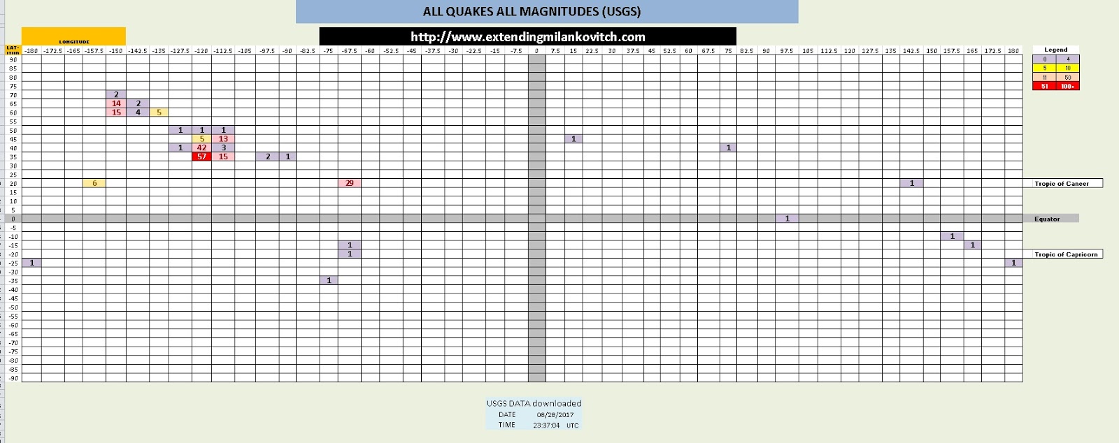
USGS DATA downloaded   
DATE 08/28/2017
TIME 23:37:04

   Geographic Distribution


Number of quakes >2.5m 44

Number of ALL QUAKES 225


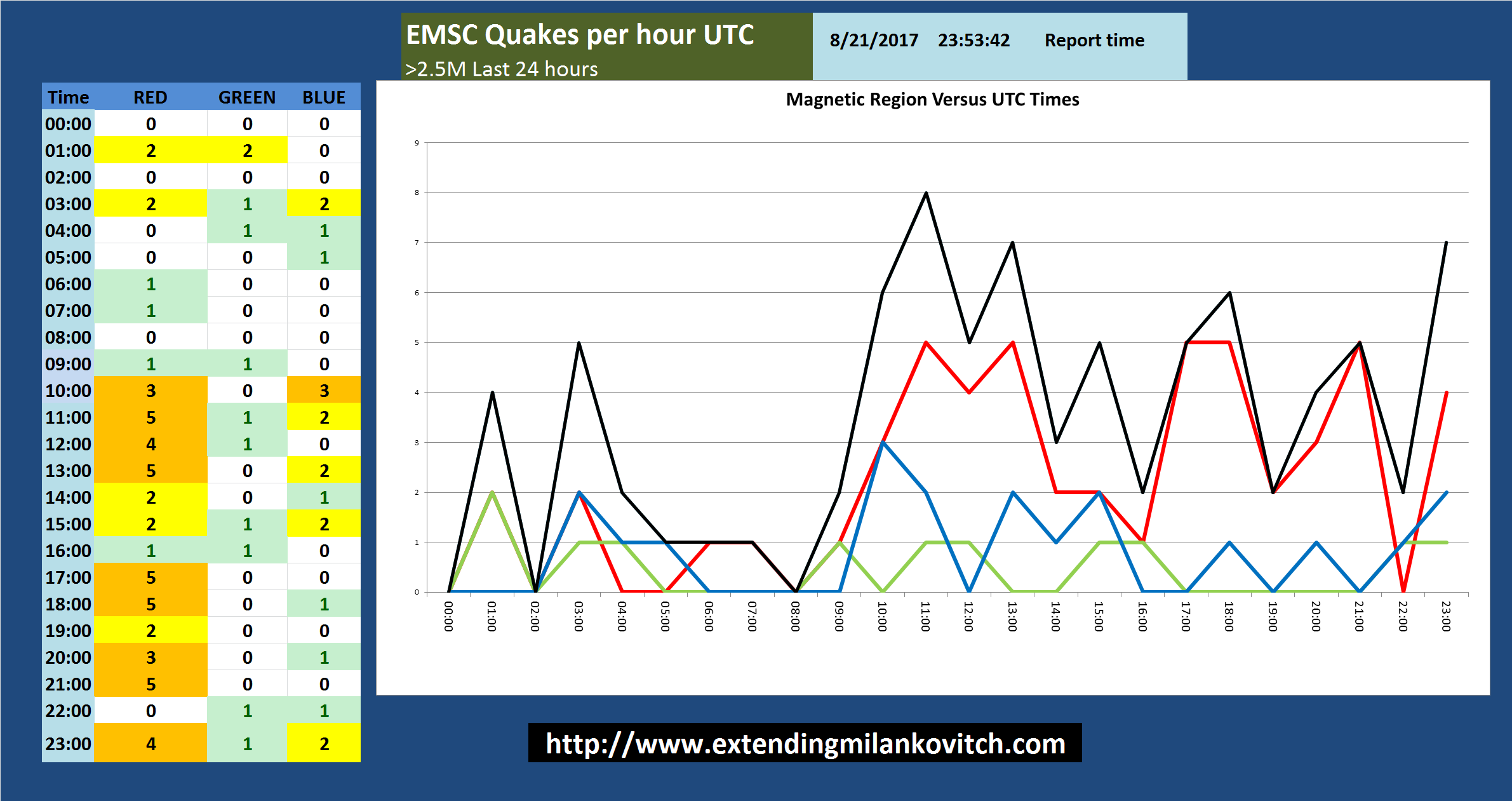
Quakes displayed by UTC Times


Highest Magnitude Quake
Depth = 33.84
Magnitude = 4.9
UTC Time = 12:06:34
36km SSW of Honiara, Solomon Islands
Deepest Quake
Depth = 490.84
Magnitude = 4.6
UTC Time = 15:58:19
South of the Fiji Islands

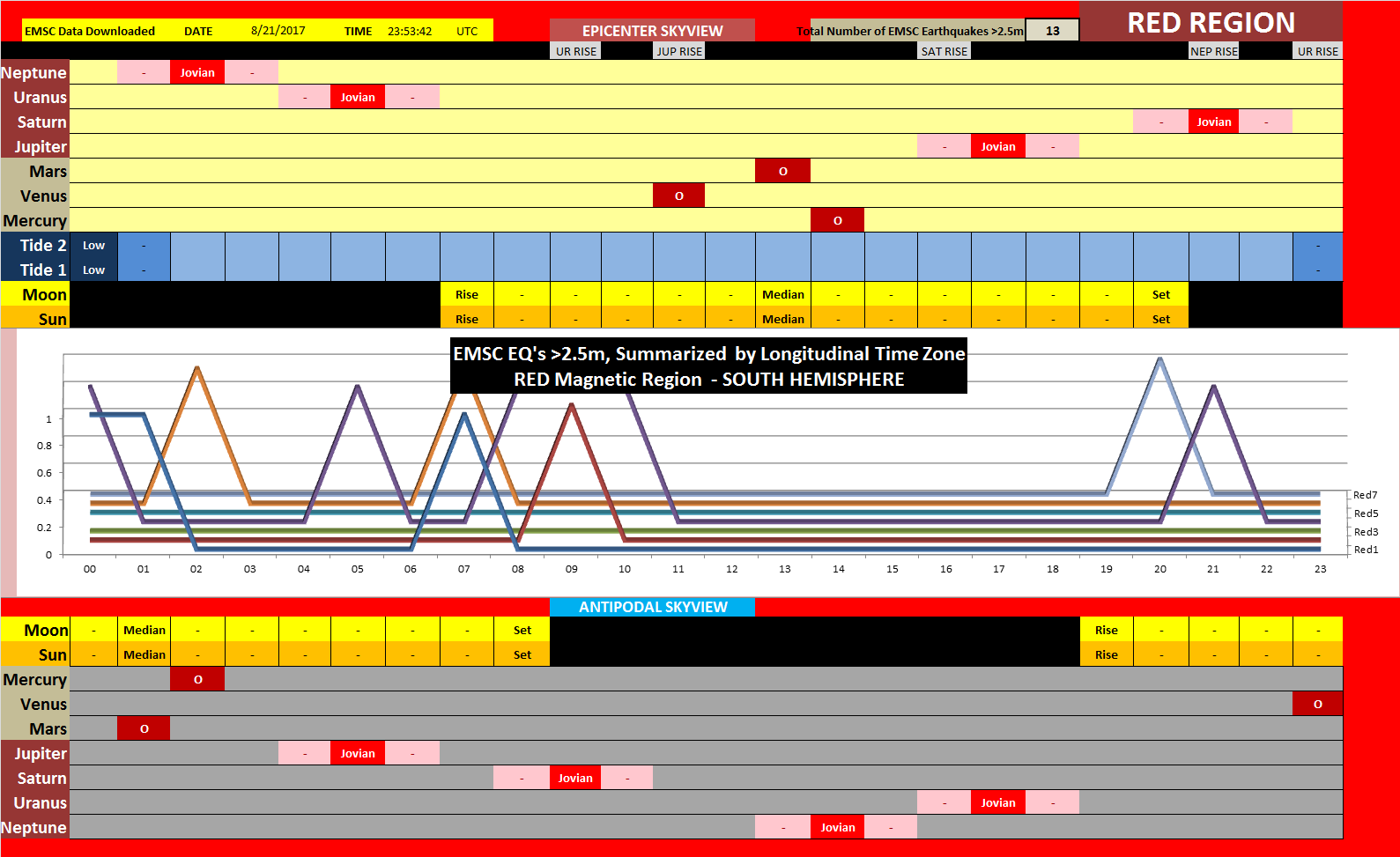
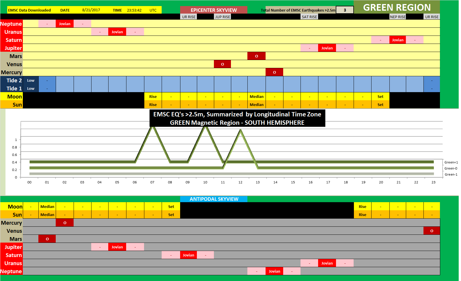
Magnetic Quake Distribution
                      Totals    Percentage %
RED 13                29.55%
Green 4                  9.09%
BLUE 27                61.36%

NOTE:  EARTHQUAKE SWARMS IN BLUE REGION AND RED REGION
             These magnetic totals are of no good TODAY

Magnitudes #
2.5m                          21
3m                             11
4m                             12
5m                              0
6m                              0
7m                              0
8m                              0
9 +                              0

                  Depth KM #
Surface            0-5            5
19                   6-15            7
                 16-25            7
Deep          26 - 50            12
24                  51 - 99             6
               100 - 199             4
               200 - 299             0
               300 - 499             2
               500 +             0


NASA JPL Lunar and Combinational Geometries


USGS Quakes >2.5m, last 24 hours

    - NASA JPL Data, Tides, Sun, and Moon

   - Summarized


   - MAGNETIC Distribution


USGS ALL Quakes ALL Magnitudes
  
   - NASA JPL Data

   - Summarized


   - MAGNETIC


USGS DATA and Calculations


8/21/2017

EMSC Network Analysis 08/21/2017

     By:  Gordon Rutherford

Cellphone Users and some Tablets, to see the videos posted on this page, you have to choose "Desktop Site" in your browser settings, otherwise even the Image Previews of videos WILL NOT BE DISPLAYED.  NOTE:  the data shared here are screenshots of data analytical tools developed, by me, that MUST BE VIEWED as "Desktop Site" or you will not be able to zoom in and see the data.

Weblink to Video: 

https://www.youtube.com/watch?v=YzbF7cuewkY


INTERACTIVE EARTHQUAKE MAP

https://www.google.com/maps/d/u/0/edit?mid=1cfS9_ZwRmMCVFuBA0AcsM3VDpX3X8lA&usp=sharing


Works Cited

Lunar Resonant Geometries - 08/21/2017

      By: Gordon Rutherford

Cellphone Users and some Tablets, to see the videos posted on this page, you have to choose "Desktop Site" in your browser settings, otherwise even the Image Previews of videos WILL NOT BE DISPLAYED.  NOTE:  the data shared here are screenshots of data analytical tools developed, by me, that MUST BE VIEWED as "Desktop Site" or you will not be able to zoom in and see the data.

Northern and Southern Hemisphere

- Planetary Spatial Separation

Web Link to Video: 

https://www.youtube.com/watch?v=kT6EQkz_RsA


WORKS CITED:

Solar Report - 08/21/2017

    By: Gordon Rutherford

Cellphone Users and some Tablets, to see the videos posted on this page, you have to choose "Desktop Site" in your browser settings, otherwise even the Image Previews of videos WILL NOT BE DISPLAYED.  NOTE:  the data shared here are screenshots of data analytical tools developed, by me, that MUST BE VIEWED as "Desktop Site" or you will not be able to zoom in and see the data.


Weblink to Video:


SOURCE DATA USED
Works Cited